
THE RIVER ROAD TO BIG BEND NATIONAL PARK
A One-Day Due South From Marfa
Stop 1: Cibolo Creek Ranch
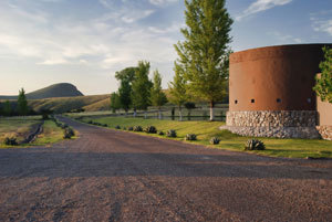
Cibolo Creek Ranch is the site of three historic adobe forts, all of which are listed in the National Historic Register. The main fort, El Cibolo, was built along Cibolo Creek by Milton Favor in the mid-1800s as defensive strongholds against local bandits and Apache and Comanche raiders.
Stop 2: Fort Leaton
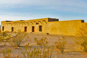
Stop four miles southeast of Presidio at Fort Leaton State Historic Site for a glimpse at the area’s cultural history. Humans have occupied this land, near the confluence of the Rio Conchos and Rio Grande, for 3,500 years. Spanish explorer Cabeza de Vaca arrived here in 1535 before venturing south into Mexico. Comanche raids and Mexican bandits threatened settlers in the area throughout the mid- to late-19th century. Indian hunter Benjamin Leaton established the fort in 1848 as a border trading post. The massive adobe fortress protected his family and employees from Indian raids.
Stop 3: River Road
One of the most scenic drives in the United States winds along the Rio Grande between Presido and Lajitas. Known as “the river road,” this memorable drive reveals remarkable geology. Stop at the Barton Warnock Environmental Center in Lajitas to learn about the 570 million years of geological history you’ve been driving through. Exhibits at the center also explain the five biological landscapes of the Chihuahuan Desert. Walk among the characteristic plants of the Big Bend region in their 2-acre botanical garden and watch for some of the 300 species of birds that have been recorded here, including Wilson’s Warblers, Western Tanagers, and Black-headed Grosbeaks.
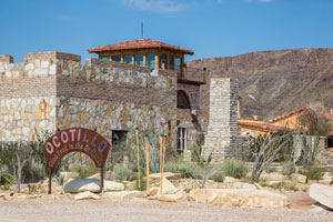
Stop 4: Terlingua Ghost Town
In Study Butte-Terlingua, turn west on 170 and head down the road a short distance to see the remnants of a mining town. “Live music is a big deal in Terlingua, especially up in the Ghostown,” explains a local resident. “You never know who you might find playing on the porch at the Trading Company, from celebrities to local characters. And don’t worry about the naked guy directing traffic; he just does that.” Be sure the Ghostown is part of your adventure.
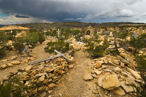
The cemetery at Terlingua’s ghost town rests about 400 souls, mainly from the early part of the 20th century when the mining town thrived for four decades. Aging wooden crosses and cone-shaped dirt and rock mounds called “relicaritos” mark the graves. The graves are predominately of middle-aged Hispanic men who died from the dangers of the area’s mercury mining. The cemetery is still in use.
Stop 5: Study Butte/Terlingua
Study Butte is pronounced so Study rhymes with duty and Butte rhymes with fruit. This bustling community serves Big Bend National Park from the north. Supplies, food, gas, Western art, and Mexican craft work are available at the local shops and eateries.
“The jagged eastern horizon, with the mighty Chisos and Sierra Del Carmen mountains, looks like something out of a Flintstones cartoon; closer in are layered canyons, cracked limestone, old riverbeds, rugged outcroppings—it’s as if the earth couldn’t make up its mind what it wanted to be here. Desert? Mountains? Hills? Yes. Enjoy the confusion of Terlingua,” writes Michael Hall in a Texas Monthly article.
Stop 6: Big Bend National Park
The drive continues along paved roads but there are few ae way, so top off your vehicle with fuel, fluids, and air for your tires to ensure a troubmenities along thle-free trip. Make sure you have a good spare and the tools to change a flat should you need to. There are limited auto services in and around the park so being prepared for simple emergencies is necessary. Don’t expect cell service on this trip; it will be spotty at best.
More than 801,000 acres of mountains and desert—the most remote park in the lower 48—await you. Just a two-hour drive from Marfa, Big Bend’s legendary Rio Grande and its tributaries cut vertical canyons through modest mountains frilled with pines and other specially adapted plants that live in the high desert.
The park requires an entrance fee that can be paid at the entrance station or any of the visitor centers.
One of the most important items to bring to Big Bend is water. Staying hydrated will make your visit safer and more pleasant. Hats, sunscreen, and clothing appropriate for the weather all make your trip more comfortable. The weather here can change considerably in just a short time, so be prepared for different conditions. Be sure to bring binoculars and a camera, too!
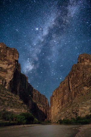
Stop 7: Santa Elena Canyon
The magnificent canyons along the Rio Grande are one of the main reasons Big Bend National Park was established, and one of the most impressive of them is Santa Elena Canyon. From the trailhead at the mouth of the canyon, the limestone walls of Santa Elena tower 1,500 vertical feet above the river. The Rio Grande flows east out of the canyon as a narrow slash only 200 feet wide before bending south at the confluence with Terlingua Creek. Stunning views along the 1.5-mile, round-trip trail into the canyon make it well worth the time and effort. Roadside exhibits at various points along the drive provide opportunities to stretch your legs and learn about the plants, people, and geology of the area. Some of the more popular stops are the Sam Nail and Homer Wilson Ranches, Castolon Historic District, and Tuff Canyon.
BEFORE YOU GO…
• Check fuel and fluid levels in your vehicle as well as tire pressure.
• Be prepared for weather; it can change quickly in Big Bend.
THINGS TO TAKE
• Spare tire
• Water
• Hat
• Sunscreen
• Extra layers
• Camera
• Binoculars

